
Based on the booklet ‘Discover Hope’ which was compiled by members of Hope Historical Society with illustrations by Keith Green
Supported by Hope, Edale and Castleton Interpretation Group and Hope with Aston Parish Council
Available from Hope Post Office / Spar, or by email from Hope Historical Society or the display at Hope Wakes Week
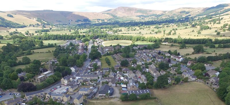
The village of Hope has an ancient history. Standing at the confluence of the River Noe and the Peakshole Water, the village was at the centre of ancient communication routes: the prehistoric Portway ran north and south through Derbyshire and passed through the village. The Roman Road, from Glossop in the west to Buxton in the south and to Templeborough near Rotherham in the east crossed the river at Hope to access the Roman Fort at Brough.
The village lies at the junction of the limestones of the Bradwell and Castleton areas, the ‘White Peak’ and the shales, sandstones and gritstones of the Edale Valley, the ‘Dark Peak’ The village looks west towards Castleton, at the upper end of the Hope Valley.
The name ‘Hope’ (from the Old English) probably means a ‘small enclosed valley’. The village is framed by Win Hill and Lose Hill. Tradition claims that the hills are named for a 7th century battle between Edwin of Northumbria and the Mercian King Penda which took place in the region. Finds of spearheads lend credence to the legend.
Hope, listed in Domesday, was the administrative centre for one of the largest medieval ecclesiastical parishes in Northern England, stretching from Glossop in the north to Buxton in the south and from Whaley Bridge in the west to Bamford in the east.
In later medieval times packhorse routes from Cheshire,carrying salt and other commodities crossed the Pennines and passed though Hope. Their tracks are visible as holloways in the local landscape.
The old village, some of the houses dating back 400 hundred years, surrounds the church and spreads up the Edale Road towards fords which crossed the Noe near the Cheshire Cheese Inn.
The appearance of the old centre of Hope has not altered much, although occupations and land use have changed. In the 18th and 19th centuries, Hope was largely an agricultural community with a few farms of moderate size and village houses with an attached smallholding, most villages farmed but also had a second occupation.
The coming of the Midland Railway in the 1890’s and the construction of Howden and Derwent Dams in the early 1900’s brought change to the village with an influx of workers with new skills. Housing development was mainly along Castleton Road.
In the 1920’s the development of the cement works by G & T Earle Ltd. brought industrial employment to the area. This was followed in the 1980’s by Carbolite plc of a factory for the manufacture of furnaces and furnace equipment on the site of the railway goodsyard.
Hope lies within the Peak District National Park (PDNP) created in 1951. Many visitors to Hope remain unaware that Hope is a working village surrounded by working hill farms and that village people find employment both at the cement works and in the tourist economy or that Hope has a thriving Primary School and Community College and that many of the inhabitants of Hope have ancestors who have lived in the area for many generations.
Hope Historical Society, assisted by Hope with Aston Parish Council produced ‘Discover Hope’ to record some of the history, tradition and legend that enriches village life and for the enjoyment of visitors.

The Parish Church of St Peter lies close to the centre of the village. The site, dates back to Saxon times, a charter of 926 records that King Athelstan bought land at Ashford and Hope from a ‘heathen Dane’. There are traces of Saxon stone carving decorating the exterior of the building. Much of the present building dates to the 14th century though the chancel was extensively rebuilt in 1882 and the east end was rebuilt in 1908.
There is an index and map of the Graves in the Churchyard, for those interested in identifying an ancestor buried there. There are a number of other interesting items within the Churchyard, including the old Market Cross and a Saxon Cross. Eccles Cross has been moved from its original position at the top of Eccles into the churchyard. The Celtic Face which is used as the Historical Society logo can be found in the north wall of the tower.
There is a Self-guided Trail exploring the medieval historical landscape between Castleton and Hope